반응형
Mount Kumgang (Korean: 금강산; RR: Geumgangsan; MR: Kŭmgangsan; lit. Diamond Mountain) or the Kumgang Mountains is a mountain massif, with a 1,638-metre-high (5,374 ft) peak, in Kangwon-do, North Korea. It is located on the east coast of the country, in Mount Kumgang Tourist Region, formerly part of Kangwŏn Province, and is part of the Taebaek mountain range which runs along the east of the Korean Peninsula. The mountain is about 50 kilometres (31 mi) from the South Korean city of Sokcho in Gangwon-do. Mount Kumgang has been known for its scenic beauty since ancient times and is the subject of many different works of art. Including its spring name, Kŭmgangsan (Korean: 금강산; Hanja: 金剛山, Korean pronunciation: [kɯmɡaŋsʰan]), it has many different names for each season, but it is most widely known today in the Korean language as Kŭmgangsan. In summer it is called Pongraesan (봉래산, 蓬萊山: the place where a Spirit dwells); in autumn, Phung'aksan (풍악산, 楓岳山: hill of colored leaves, or 楓骨山: great mountain of colored leaves); in winter, Kaegolsan (개골산, 皆骨山: stone bone mountain).
.
The creation of Mt. Kŭmgang is closely related to the unique climate and distinctive geological activity of the area. Mt. Kŭmgang is a region where rain and snow fall relatively heavily, and the climate varies depending on altitude and even east-west location. The Kŭmgang geological layer is composed of several types of rocks from ancient geological periods. The most widely distributed rocks are granites of two types (mica mixed and stained), with granite-gneissic fertilization zones being formed in some areas. The rocks are transversely oriented and form a joint in various directions, forming unusual terrains and strange rocks, which have been formed as a result of erosion for a long period of crustal activity and weathering, from 10 million years to the present.
.
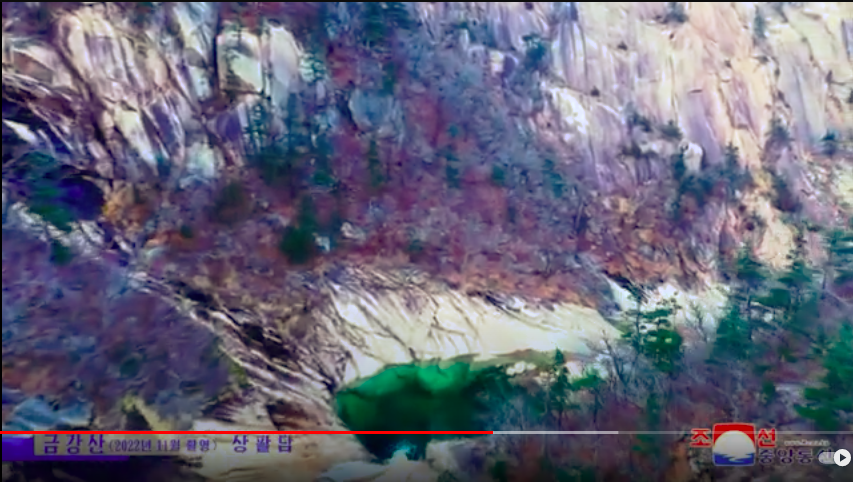
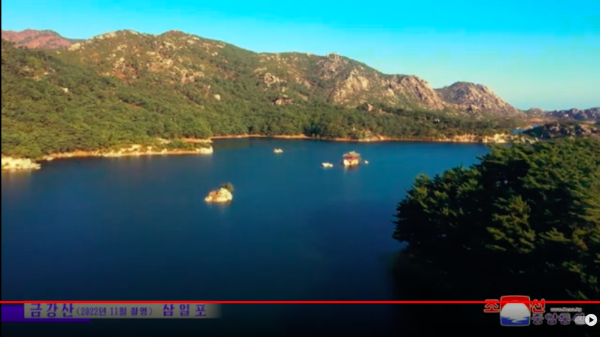
Kŭmgang Mountain ranges from Tongcheon-gun, Gangwon-do in the Democratic People's Republic of Korea, to Inje-gun, Gangwon-do in the Republic of Korea. The area is up to 40 km long east–west, 60 km north–south, with a total size of 530 km² to the back of Baekdudaegan. It is divided between the "Inner Kumgang" in the west and the "Outer Kumgang" in the east. The area on the east side of the Yeongeum River is called "Hae Kumgang" ("Sea Kumgang"). The main peak of Mt. Kŭmgang is Pirobong, and there are more than 60 peaks over 1,000 meters. Combined with countless sub-peaks, they were historically called "12,000 peaks". Many scenic spots in the area are designated as natural monuments of the Democratic People's Republic of Korea. The southern part of the "Outer Kumgang" is also called "New Kumgang". There are 11 areas in Outer Kumgang, 8 in Inner Kumgang and 3 in Hae Kumgang, although not all have been opened. Since ancient times, the name Kumgang has been mainly used for the "Inner Kumgang" (내금강), which, located in the western part of the central pole, contains the main peak of Mount Kŭmgang. "Outer Kumgang" (외금강) is located to the east of the "Inner kumgang" and covers an area along the east coast. The Outer Kŭmgang area is noted for the large number of peaks. Chipson Peak (literally "rock of ten thousand forms") is known for its many waterfalls. It includes many mountain peaks including Moonjoo Peak, Ho Peak, Sangdeung Peak, etc. The "Sea Kŭmgang" area is known for the lagoons and stone pillars. Kuryong Falls ("Nine Dragons Falls") in Kuryongyeon is one of the three major waterfalls in Korea along with Daeseung Falls in Seoraksan. It is 74 meters in height and 4 meters in width. The waterfall cliffs and the bottom are made of one granite mass. Bibbong Waterfall is 139 meters higher, and is named for its refreshing water stream. The rocks there are associated with unique legends.
.
covered by mixed broadleaf and coniferous forest and protected in a 60,000 ha national park. Some 25,000 ha has been identified by BirdLife International as an Important Bird Area (IBA) because it supports endangered red-crowned cranes. It belongs to the alpine region and has relatively high rainfall, with heavy rainfall in July and August. The East-West difference is severe, and the rainfall increases from Haegeumgang to Oegeumgang, but due to the phenomenon of Foehn, the rainfall decreases from Naegeumgang to Naegeumgang. It is also warm and humid in preparation for the overall climate in Korea.However, depending on the altitude, cold temperatures of minus 10 to 30 degrees Celsius will continue in the winter, and depending on the region, snow will fall as early as October. These climatic conditions lie at the intersection of the northern and southern plants.[
.
+++
반응형
'2. Humanities > 26_北韓과中國' 카테고리의 다른 글
| 003. 북조선중앙통신이 전하는 평양의 가을풍경 모음 - Fall in Pyungyang by North Korea Central News (0) | 2023.04.12 |
|---|---|
| 002. 북조선중앙통신이 전하는 평양의 봄풍경 - Spring in Pyungyang by North Korea Central News (0) | 2023.04.11 |
| 중국 우주과학의 아버지 첸쉐싼(錢學森전학삼)[중국근현대인물] (1) | 2022.12.29 |
| ‘북에서 온 黨 연락대표’라며 南 인사들 포섭 공작...아무도 신고하지 않았다 (0) | 2021.08.14 |
| [종북 주사파 자생적 공산주의(친북좌파) 운동권을 위한 일리있는 변명] (0) | 2020.05.12 |